
Himalaya/Plain and Plateaus/Coastal Plain and Islands
http://ias-cracker.tk
Himalayan Physiography Northern Plains, Plateaus and Desert Coastal Plains and Islands
Himalayan Physiography
India is the seventh largest in terms of area (32, 87,263 km2) and second most populous country in the world accounting for about 2.4% of the total world area. It lies in the northern hemisphere between the 804’ N and 3706’ N parallel of latitude and the 6807’ E and 97025’ E meridians of longitude, and is a part of the Asian Continent.
• The peninsular part of the India extends itself into the Indian Ocean dividing it into the Arabian Sea and the Bay of Bengal.
• In the oceanic and sea water India claims a 12 nautical mile of territorial waters and an exclusive economic zone of 200 nautical miles.
• India has accounted to 6,100 km. of mainland coastline and total including island is 7,516.6 km.
• India shares total of 15,200 km. land frontier with six nations those are: Pakistan (3,310 km), China (3,917 km), Nepal (1,752 km), Bhutan ( 587 km), Bangladesh ( 4,096 km) and Myanmar (1,458 km).
• India’s total land mass is divided into four main geological featured regions as, northern mountains, northern plains, peninsular region and coastal plains.
NORTHERN MOUNTAIN COMPLEX (HIMALAYA):
• This is among the youngest mountain ranges on the planet and highest mountain range in the world which separating the Indian subcontinent from the Tibetan Plateau.
• It is the source of two of the world’s major river systems- the Indus basin and the Ganga-Brahmaputra Basin.
• This range is divided into:
A. The Himalayas:
• The central axial length of the Himalayas is about 2400 km. from Nanga Parbat in the west to Namcha Barwa in the east.
• Himalayan ranges are considered extension of the trans-Eurasian mountain ranges and Pamir knot (roof of the world) is the connecting link between these ranges.
• It is estimated that the Indian plate is still moving northward at a rate of about 5cm. per year.
• This is not a single range but series of chain of mountains. Suleman, kirthar, kulung shang, Tian sang, Arkanyoma , Pegayoma are the well known mountain ranges situated in this mountain.
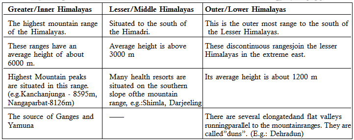
North- south division of Himalayas
– Great Himalayas (Himadri)
– Middle/ Lesser Himalayas (Himachal)
– Shivalik (outer Himalayas)
– Great Himalayas (Himadri)
– Middle/ Lesser Himalayas (Himachal)
– Shivalik (outer Himalayas)

East-West division of Himalayas
Western Himalaya:
• Its extent is about 880 km between the Indus in the west and the Kali river in the east. The western Himalayas spread in three states of Jammu and Kashmir Himalaya, Himachal Himalaya, and Kumaon Himalayas, respectively.
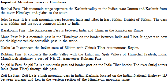
• The northern slopes are gentler and are bare and show plains with lakes, while the southern slopes are rugged and forested. Zojila, Rohtang, Bara Lacha la and Shipki La are important passes.
• This area has the beautiful valleys of Kullu, Kangra and Lahul and Spiti.
Central Himalaya:
• It stretches between the river Kali in the west and river Tista in the east for a distance of about 800 km.
• It lies mainly in the Nepal. All the three ranges of the Himalayas are present here.
• The great Himalayas attain maximum height here. Yepokangara, Lidanda, Chuuling, Annapurna, Mayondi are glaciers are present in this region.
Eastern Himalaya:
• This lies between the Tista river in the west and the Brahmaputra river in the east.
• Its extent is about 720 km. It occupies mainly the areas of Arunachal Pradesh and Bhutan.
• Important mountain passes are Zelap la, Bum la, Tse la, Tunga, Yonggypa and Kengri Karpo la.
• In this region of Himalayas, due to heavy rain fall by south west monsoon and north east causes heavy fluvial erosion.
• The Himalayas take a knee bend southward turn beyond Dihang george, running more or less along India’s border with Myanmar known as Purvanchal Hills.
• Locally they are known as Patkai Bum, Naga Hills, Kohima Hills, Manipur Hills, Mizo Hills (Lushai Hills), Tripura Hills and Barail ranges.
B. Trans Himalayan mountain region or Tibetans Himalayan Region:
This region is located to the north of the great Himalayas which is consists of Karakoram, ladakh, zhaskar and kailash mountain range. It is also called the Tibetans Himalayan region because most of the part of this range lies in the Tibet. The Karakoram range is known as ‘backbone of high Asia’. K2 is the second highest pick in the world and highest in the Indian Territory.
C. Eastern Hills or the Purvanchal Hills
After crossing the Dihang gorge (Brahmaputra gorge), the Himalayas Suddenly turn southward and form a series of comparatively low hills running in the shape of a crescent with its convex side pointing towards the west.
After crossing the Dihang gorge (Brahmaputra gorge), the Himalayas Suddenly turn southward and form a series of comparatively low hills running in the shape of a crescent with its convex side pointing towards the west.
These hills are collectively called the Purvanchal because they are located in the eastern part of the country. It extends from Arunachal Pradesh in the north to Mizoram in the south and form boundary between India and Myanmar.
The Indo-Burma hill range is a part of the Arakan Yoma Suture zone that stretches south through Andaman – Nicobar island chain to Sunda. The elevation of the Eastern Hills (Purvanchal) decreases from north to south and it is characterized by rough terrain, dense forests and swift streams. All these Ranges are generally 2,000m or less in height but are rather forbidding because of dense forests, very rough terrace and inhospitable tribe.
It comprises of the following hills –
a. Mishmi hills – Contains the loftiest range of the Purvanchal. Dapha Bum is its highest peak.
b. Patkai Bum Range – It is the northernmost range forming the easternmost limit of the Great Himalaya Mountains, has synclinal structure and is made up of Tipam sandstone.
c. Naga Hills – It lies south to the Patkai Bum and Saramati (3826m) is its highest peak. Patkai Bum and Naga hills form the watershed between India and Myanmar.
d. Manipur Hills – It is south to Naga hills and form boundary between Manipur and Myanmar. Its central part is a large basin which appears to be bed of an old lake, a remnant of which occupies the south-east corner of the basin and is known as Loktak Lake. The Barail Range separates Naga Hills from Manipur hills.
e. Mizo Hills (Lushai Hills) – It lies south to the Manipur hills and its highest point is the Blue Mountain (2157m) in the south.
SIGNIFICANCE OF HIMALAYA FOR INDIA:
• Strategic significance: Acts as a natural frontier of India with other countries (China, Afghanistan and Pakistan).
• Climatic significance: Prevent further northward movement of summer monsoon and also prevent cold northern winds from Siberia to enter into India.
• Physical significance: The glaciers of the Himalayas feed the perennial rivers of North India. The rivers erode the mountain ranges and deposit the alluvial soils which are highly productive.
• Agricultural Significance: Rivers from Himalayas deposits a lot of sediment on its foothold, from which are formed India’s most fertile agricultural grounds known as Northern plains. The water of the mightly rivers arising out of the Himalayas is utilized for irrigation, industrial and domestic purpose. Alpine pastures provide nutritious grasses to the flock of transhumans. Tea, nuts, saffron, Apples and orchard plantation on the undulating slopes.
• Economic significance: Huge hydro-electric power potential of Himalayan rivers, Himalayan timber, Himalayan Herbs & Medicinal plants. River sediments are used for a great source of minerals and building material.
• Tourism Significance: Comprises of Large ecological biodiversity, natural views & hill stations. Abode of numerous tribes. The Himalayas are rich in flora and fauna. Natural beauty, hill resorts, and tourism. Great religious and mythological importance.
Union Legislature/State Legislature
Union and State Legislature The State Legislature
Union and State Legislature
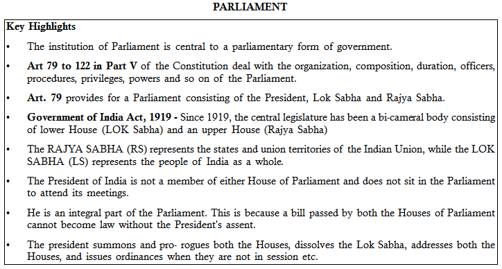
Functions of Parliament
a) Law making functions
b) Providing the Cabinet: It is the Parliament which provides the cabinet. No person can continue to be a minister for more than six months unless he is member of either House of the Parliament.
c) Control over the Cabinet: It is one of the more important functions and duties of the Lok Sabha to ensure that the ministry remains in power only as long as it has the support of the majority in that house [Art.75(3)].
d) Daily Answerability: In the Parliamentary system of Government the ministers have to answer questions, reply to calling attention motions, move legislation and justify Government’s actions in both Houses of Parliament.
e) Financial Control: An important function of Parliament is to exercise financial control over the government. Parliament also monitors spending of government money through its own committee called Parliamentary Accounts Committee (PAC).
f) A Platform for discussion on National Issues: Parliament provides the single largest platform for discussion of all important national and public issues and thereby it creates public opinion on these issues.
Qualifications and disqualifications for being a Member of Parliament
To be qualified to become a Member of Parliament a person must be:
To be qualified to become a Member of Parliament a person must be:
a) A citizen of India;
b) Not less than 30 years of age in the case of the Rajya Sabha and not less than 25 years in the case of the Lok Sabha
c) A voter for any parliamentary constituency in India, but in the case of the Rajya Sabha a candidate must be registered as an elector in the State or Union Territory from where he is to be chosen.
There are, however, certain disqualifications for becoming a member. A person would be ineligible for being a member of either House of Parliament if the person:
a) Holds any office of profit under the government other than an office declared by Parliament by law not to disqualify its holder
b) Is of unsound mind;
c) Has ceased to be a citizen of India;
d) Is so disqualified by any law made by Parliament;
e) Is so disqualified on the ground of defection.
f) If a person has been convicted, among other things, for promoting enmity between different groups or convicted for the offence of bribery or has been punished for preaching and practicing social crimes such as untouchability, dowry, or sati, then he is disqualified from being chosen as a member.
g) There are also disqualifications for a government servant dismissed for corruption.
RAJYA SABHA
Composition
a) The Rajya Sabha is the permanent upper House and not subject to dissolution.
b) It is composed of not more than 250 members.
c) Out of these 238 are to be the representatives of the State and the Union Territories and 12 are to be nominated by the President.
d) Persons to be so nominated are required to have special knowledge or practical experience in respect of literature, science, art or social service.
e) The object of this nomination is to provide distinguished persons a place in the Rajya Sabha without going through the process of election.
Election – The representatives of the States are elected indirectly by the elected members of State Legislative Assemblies in accordance with the system of proportional representation by means of a single transferable vote.
LOK SABHA
Composition
a) The maximum strength of Lok Sabha is 552 of which 530 are elected from the states, 20 from union territories and 2 are nominated from the Anglo-Indian community.
b) The Constitution prescribes the numbers of seats in the Lok Sabha to be divided between the States and the Union territories.
c) The allocation of seats in the Lok Sabha to a particular state and division of each state into territorial constituency is done on the recommendation of the Delimitation Commission (Art. 82), which is appointed after the completion of each census.
d) By 42nd Amendment Act, 1976 the allocation and division had been frozen till the year 2000.
e) By 87th Amendment Act, 2003 it has been laid down that the allocation of seats to a State shall remain frozen till 2026.
f) The division of the State into territorial constituencies shall be done on the basis of the census figures of 2001 census.
National Policy for Women, 2016
National Policy for Women, 2016
Ministry of Women and Child Development has unveiled the draft National Policy for Women 2016.
Salient features of the National policy for women empowerment:
a) To create a society with women working as equal partners in all spheres of life
b) To develop a framework to ensure equal rights and opportunities for women
c) To make cyber space a safe place for women and to address “redistribution of gender roles, for reducing unpaid care work, review of personal and customary laws in accordance with the Constitutional provisions and many more.”
d) It also seeks to review the criminalization of marital rape keeping women’s rights in mind.
e) Health and education of women have been kept a priority in the proposed draft.
f) The draft has proposed to “improve access to pre-primary education, enrolment and retention of adolescent girls.”
g) To carry out skill development and provide equal employment opportunities.
h) To provide suitable benefits related to maternity and child care services.
i) The draft plans to increase women’s participation in the political, administration, civil services and corporate boardrooms arena.
j) To address all forms of violence against women
k) To improve child sex ratio (CSR)
l) To prevent trafficking at source, transit and destination areas for effective monitoring of the networks.
m) Operational strategies
n) To enable safety and security of women with the help of “One Stop Centres, Women Helpline, Mahila Police Volunteers, Reservation of women in police force, Panic buttons in mobiles, Surveillance mechanisms in public places.
o) To create eco-systems to encourage entrepreneurship amongst women. This has been proposed to be done through podiums like Mahila E-Haat et.
p) Aiding women in workplace through “flexi timings, increased maternity leave, provision of child care/creches at workplace, life cycle health care facilities.”
Neeranchal National Watershed Project
Neeranchal National Watershed Project
• Neeranchal will lead to reducing surface runoff of rainwater, increasing recharge of ground water and better availability of water in rainfed areas resulting in incremental rainfed agriculture productivity, enhanced milk yield and increased cropping intensity through better convergence related programmes in project areas.
• The project will be implemented by the Ministry of Rural Development.
• It is a six-year period (2016-21) will support the Pradhan Mantri Krishi Sinchayi Yojana in hydrology and water management, agricultural production systems, capacity building and monitoring and evaluation.
• The Neeranchal project was approved by the cabinet with Bugdet sharing of 50% by Govt and rest 50% by the World Bank.
• All 28 states which implement the watershed projects will benefit from Neeranchal.
• 12% of the area which can be called as wasteland will be targeted through this project to make about 336 lakh hectares of land arable.
• Neeranchal is primarily designed to address the following concerns:
a) Bring about institutional changes in watershed and rainfed agricultural management practices in India,
b) Build systems that ensure watershed programmes and rainfed irrigation management practices are better focussed, and more coordinated, and have quantifiable results,
c) Devise strategies for the sustainability of improved watershed. Management practices in programme areas, even after the withdrawal of project support,
d) Through the watershed plus approach, support improved equity, livelihoods, and incomes through forward linkages, on a platform of inclusiveness and local participation.
Hydroponics
Hydroponics
Hydroponics is a subset of hydroculture, the method of growing plants without soil, using mineral nutrient solutions in a water solvent. Terrestrial plants may be grown with only their roots exposed to the mineral solution, or the roots may be supported by an inert medium, such as perlite or gravel. The nutrients in hydroponics can be from fish waste, duck manure, or normal nutrients.
With hydroponics the plants are grown in an inert growing medium and a perfectly balanced, pH adjusted nutrient solution is delivered to the roots in a highly soluble form. This allows the plant to uptake its food with very little effort as opposed to soil where the roots must search out the nutrients and extract them. This is true even when using rich, organic soil and top of the line nutrients. The energy expended by the roots in this process is energy better spent on vegetative growth and fruit and flower production.
Advantages
• No soil is needed for hydroponics.
• The water stays in the system and can be reused – thus, a lower water requirement.
• It is possible to control the nutrition levels in their entirety – thus, lower nutrition requirements.
• No nutrition pollution is released into the environment because of the controlled system.
• Stable and high yields.
• Pests and diseases are easier to get rid of than in soil because of the container’s mobility.
• Ease of harvesting.
• No pesticide damage.
Disadvantages
Without soil as a buffer, any failure to the hydroponic system leads to rapid plant death. Other disadvantages include pathogen attacks such as damp-off due to Verticillium wilt caused by the high moisture levels associated with hydroponics and over watering of soil based plants. Also, many hydroponic plants require different fertilizers and containment systems.
Without soil as a buffer, any failure to the hydroponic system leads to rapid plant death. Other disadvantages include pathogen attacks such as damp-off due to Verticillium wilt caused by the high moisture levels associated with hydroponics and over watering of soil based plants. Also, many hydroponic plants require different fertilizers and containment systems.

Thanks for giving an excellent blog, keep on posting this blog..
ReplyDeleteAir Hostess Training Institute in chennai
Aviation Courses in Chennai
aviation institute in bangalore
airport management courses in chennai
airport management courses in bangalore
airport management courses in chennai
Air Hostess Training in Bangalore
airport ground staff training courses in chennai
Ground staff training in Bangalore
airport ground staff training courses in chennai