
Jet Streams/Air Mass/Fronts and Cyclones
Jet Streams Air Masses Fronts and Cyclones
Introduction
• A jet stream develops where air masses of differing temperatures meet. Therefore, the surface temperatures determine where the jet stream will form.
• The greater the difference in temperature, the faster the wind velocity inside the jet stream.
• Jet streams can flow up to 200 mph (322 km/h), are 1000’s of miles long, 100’s of miles wide, and a few miles thick.
• The greater the difference in temperature, the faster the wind velocity inside the jet stream.
• Jet streams can flow up to 200 mph (322 km/h), are 1000’s of miles long, 100’s of miles wide, and a few miles thick.
Where the jet stream begins?
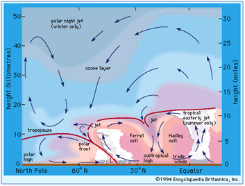
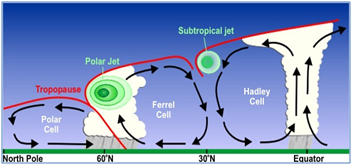
• Air warmed in the tropics around the equator fuels the jet stream as it rises.
• Hitting the tropopause at about 58,000 feet (the layer of the atmosphere separating the troposphere from the stratosphere), it is drawn toward the colder air at the north and south poles.
How does it form a convection cell?
At higher latitudes, the warm air cools and sinks, drawing more warm air in behind it. The cooled air flows back towards the equator, creating a loop or convection cell.
Why the jet stream flows on an easterly course?
As the earth rotates on its axis, so does the air around it. Due to this easterly rotation, rising warm air builds up momentum going the same direction. Thus, the jet stream cannot flow due north or due south, but makes an angular approach from the west, toward both poles.

TYPES OF JET STREAMS
Subtropical Jet Streams
• These jets, like the polar-front jets, are best developed in winter and early spring.
• During summer, in the Northern Hemisphere, the subtropical jet weakens considerably, and it is only identifiable in sporadic velocity streaks around the globe.
• During winter, subtropical jets intensify and can be found between 20° and 50° latitude.
• Their maximum speed approaches 300 knots, although these higher wind speeds are associated with their merger with polar-front jets.
• The core is most frequently found between 35,000 and 40,000 feet.
• A subsidence motion accompanies subtropical jets and gives rise to predominantly fair weather in areas they pass over.
• These jets are also remarkably persistent from time to time, but they do fluctuate daily.
• Sometimes they drift northward and merge with a polar-front jet. Over Asia in summer, the subtropical jet is replaced by the tropical easterly jet stream.
Tropical Easterly Jet Stream
• This jet occurs near the Tropopause over Southeast Asia, India, and Africa during summer.
• The strongest winds are over southern India, but they are not as intense as the winds encountered in polar-front or subtropical jet streams.
• This jet is closely connected to the Indian and African summer monsoons.
• The existence of this jet implies that there is a deep layer of warm air to the north of the jet and colder air to the south over the Indian Ocean.
• This warm air is of course associated with the maximum heating taking place over India in summer, while the colder air is over the ocean.
• The difference in heating and cooling and the ensuing pressure gradient is what drives this jet stream
Polar-Night Jet Stream
• This jet meanders through the upper stratosphere over the poles.
• It occurs only during the long winter night. Night is 6 months long over the pole in which winter is occurring.
• The polar stratosphere undergoes appreciable cooling due to the lack of solar radiation. The horizontal temperature gradient is strongly established between the equator and the pole, and the pressure gradient creates this westerly jet.
• The temperature gradient breaks down intermittently during middle and late winter in the Northern Hemisphere, therefore, the jet is intermittent at these times.
• In the Southern Hemisphere the temperature gradient and jet disappear rather abruptly near the time of the spring equinox.
SIGNIFICANCE OF THE JET STREAM
Aviation
• In terms of commercial usage, the jet stream is important for the airline industry. By flying well within the jet stream at 25,000 feet (7,600 meters), the flight time gets reduced significantly. The reduced flight time and aid of the strong winds also allows for a reduction in fuel consumption.
Weather
• One of the most important impacts of the jet stream though is the weather it brings. Because it is a strong current of rapidly moving air, it has the ability to push weather patterns around the world.
• As a result, most weather systems do not just sit over an area, but they are instead moved forward with the jet stream. The position and strength of the jet stream then helps meteorologists forecast future weather events.
• In addition, various climatic factors can cause the jet stream to shift and dramatically change an area’s weather patterns.
• The world’s jet streams are also impacted by El Nino and La Nina. During El Nino for example, precipitation usually increases in California because the polar jet stream moves farther south and brings more storms with it.
• Conversely, during La Nina events, California dries out and precipitation moves into the Pacific Northwest because the polar jet stream moves more north. In addition, precipitation often increases in Europe because the jet stream is stronger in the Northern Atlantic and is capable of pushing them farther east.
• Today, movement of the jet stream north has been detected indicating possible changes in climate.
• Whatever the position of the jet stream, though, it has a significant impact on the world’s weather patterns and severe weather events like floods and droughts.
How do the Jet Streams affect the Monsoons and the Indian Sub Continent?
Over the Indian subcontinent, there are a number of separate jet streams whose speed varies from 110 km/h in summer to about 184 km/h in winter.
Over the Indian subcontinent, there are a number of separate jet streams whose speed varies from 110 km/h in summer to about 184 km/h in winter.
Winters
• In winter the sub-tropical westerly jet streams bring rain to the western part of India, especially Himachal Pradesh, Haryana and Punjab.
• In winter the sub-tropical westerly jet streams bring rain to the western part of India, especially Himachal Pradesh, Haryana and Punjab.
Summers
• In summer the sub-tropical easterly jet blows over Peninsular India approximately at 14N and bring some rain and storm.
Monsoons
• With respect to the monsoons of India it is the Subtropical Jet Stream (STJ) and the countering Easterly Jet that are most important. As the summertime approaches there is increased solar heating of the Indian subcontinent, this has a tendency to form a cyclonic monsoon cell situated between the Indian Ocean and southern Asia.
• This cell is blocked by the STJ which tends to blow to the south of the Himalayas; as long as the STJ is in this position the development of summer monsoons is inhibited.
• During the summer months the STJ deflects northwards and crosses over the Himalayan Range. The altitude of the mountains initially disrupts the jet but once it has cleared the summits it is able to reform over central Asia.
• With the STJ out of the way the sub continental monsoon cell develops very quickly indeed, often in a matter of a few days. Warmth and moisture are fed into the cell by a lower level tropical jet stream which brings with it air masses laden with moisture from the Indian Ocean.
• As these air masses are forced upward by north India’s mountainous terrain, the air is cooled and compressed, it easily reaches its saturation vapor point and the excess moisture is dissipated out in the form of monsoon rains.
• The end of the monsoon season is brought about when the atmosphere over the Tibetan Plateau begins to cool; this enables the STJ to transition back across the Himalayas. This leads to the formation of a cyclonic winter monsoon cell typified by sinking air masses over India and relatively moisture free winds that blow seaward.
• This gives rise to relatively settled and dry weather over India during the winter months.
• Atmospheric changes over the southern Pacific Ocean led to warmer than usual waters flowing into the Indian Ocean. This provided additional moisture to feed the monsoon systems.
• Further to the north the polar jet stream stalled due to being countered by Rossby Waves, there was a large kink in the stream and this was centred over Russia. The stalled system prevented weather systems being drawn across Russia and the kink acted as a barrier trapping hot air to the south and cold air to the north.
• The consequence of this static mass of hot air was the heat wave that devastated Russia. With the jet stream stalled the STJ was unable to transit across the Himalayas as it would do ordinarily, the monsoon cell to the south, fed by warmer waters in the Indian Ocean, had nowhere to go and as a consequence it deposited vast amounts of rain over Pakistan, Himachal Pradesh and Jammu and Kashmir and this led to extensive flooding.
1. The Somali Jet Stream
• The monsoon wind that is deflected to the north as it crosses the equator is further deflected to the east by the mountains of Africa.
• Further, the progress of the southwest monsoon towards India is greatly aided by the onset of certain jet streams including the crucial Somali jet that transits Kenya, Somalia and Sahel and exits the African coast at 9 degrees north at low level and very fast.
• This low level jet stream was found to be most pronounced between 1.0 and 1.5 km above the ground.
• It was observed to flow from Mauritius and the northern part of the island of Madagascar before reaching the coast of Kenya at about 3º S. Subsequently it ran over the plains of Kenya, Ethiopia and Somalia before reaching the coast again around 9º N.
• The jet stream appears to be fed by a stream of air, which moves northwards from the Mozambique Channel.
• The major part of this low level jet penetrates into East Africa during May and, subsequently, traverses the northern parts of the Arabian Sea before reaching India in June.
• Observations suggest that the strongest cross equatorial flow from the southern to the northern hemisphere during the Asian Summer Monsoon is in the region of the low level jet.
• This has intrigued meteorologists, because it is not clear why the major flow of air from the southern to northern hemisphere should take place along a narrow preferred zone off the East African coast.
• The importance of the low level jet arises from the fact that its path around 9º N coincides with a zone of coastal upwelling. As the strong winds drive away the surface coastal waters towards the east, extremely cold water from the depths of the sea rise upwards to preserve the continuity of mass. This upwelling is brought about by strong low level winds.
• After the low level jet moves towards the Indian coastline around 9º N, it separates into two branches. One appears to move to the northern parts of the Indian Peninsula while the other recurves towards the southern half of the Indian coastline and Sri Lanka.
• Conclusively, an increase in the cross-equatorial flow was followed by an increase in rainfall over the west coast.
2. The Somali Ocean Current
• This ocean current named the Somali Current, flows northward from the equator to 9º N, where it separates from the coast. It is a fairly strong current.
• The Somali Current may be considered to be a western boundary current of the Indian Ocean. But, its peculiar feature is a reversal in direction with the onset of the summer monsoon.
• In winter, this current is from north to the south running southwards from the coast of Arabia to the east African coastline; but with the advent of the summer monsoon it reverses its direction and flows from the south to the north.
• This suggests a relationship with the reversal of monsoon winds, but usually the oceans respond very slowly to changes in atmospheric circulation.
3. Sub-tropical Westerly and Tropical Jet Streams
• Certain interesting changes take place in the upper atmosphere with the advent of the summer monsoon.
• Towards the end of May, a narrow stream of air, which moves from the west to the east over northern India, suddenly weakens and moves to a new location far to the north of the Himalayas. This is known as sub-tropical westerly jet stream.
• Its movement towards the north is one of the main features associated with the onset of the monsoon over India.
• As the westerly jet moves north, yet another jet stream sets in over the southern half of the Indian peninsula. This flows in the reverse direction from the east to west. It is called tropical easterly jet, and it exhibits periodic movements to the north and south of its mean location during the hundred-day monsoon season beginning with the first of June and ending around mid-September.
• The altitude at which the winds attain their maximum strength in the tropical easterly jet is around 150 hPa, but the maximum winds associated with the sub-tropical westerly jet occur at a lower altitude of 300 hPa. (HPa refers to ‘hecta Pascal’ and is a unit of measure of atmospheric air pressure)
• A remarkable feature of the tropical easterly jet is that it can be traced in the upper troposphere right up to the west coast of Africa.
Writs and Terms Related to Doctrines
Writs and Doctrines
WRITSIntroduction
• Under Article 32, the Supreme Court can issue the following five writs for restoration of fundamental rights:
• Habeas Corpus: It literally means “To have a body” i.e. to be produced in person before the court. This kind of writ is issued to protect the personal liberty of an individual against the arbitrary action of both the State and Private individuals. The aggrieved person can even claim for compensation against state action.
• Mandamus: It literally means “Command”. This kind of writ is issued against a public authority or a public officer and interior courts for the purpose of enforcing rights only. It is the command by the Court to the public person or body, to do his or its duty. However, this writ cannot be issued against the President and the Governors. Also, private rights cannot be enforced by this writ.
• Prohibition: This kind of writ is issued by the higher courts to the lower courts or quasi-judicial bodies (tribunals etc.) when the latter exceeds their jurisdiction. The objective is to keep the inferior courts or the quasi-judicial bodies within the limits of their respective jurisdiction.
The difference between ‘Mandamus’ and ‘Prohibition’ is that while the former can be issued against judicial as well as administrative authorities, the latter is issued only against the judicial or quasi judicial authorities.
• Certiorari: It is similar to prohibition. The only difference is that this writ is issued to quash the order of a lower court or the decision of a tribunal in excess of its jurisdiction, while Prohibition is issued to prevent an inferior court or tribunal to go ahead with the trial of a case in which it has assumed excess of jurisdiction. The purpose of this writ its to ensure that the jurisdiction of an inferior court or tribunal is properly exercised and that is does not usurp the jurisdiction it does not possess.
• Quo Warranto: It literally means ‘what is your authority’. This kind of a writ is issued to ensure that the person holding a public office is qualified to hold the office. No time limit is prescribed for issuing the writs in the Constitution and it has been left to the courts to decide on this issue.
Difference between the Writ Jurisdiction of the Supreme Court and High Court:
• The SC issues a writ (under Article 32) only in cases of the violation of the Fundamental Rights, whereas the High Court (under Art 226) can issue the writs not only for the enforcement of the Fundamental Rights but also for redressal of any other injury or illegality, provided certain conditions are satisfied. Thus in a way, the writ jurisdiction of the High Court is wider than the SC.
• Article 32 imposes on the SC a duty to issue the writs, whereas no such duty is imposed on the High Court by Article 226.
• The Jurisdiction of the SC extends all over the country, whereas that of the High Court only to the territorial confines of the particular state and Union Territory to which its jurisdiction extends.
TERMS RELATED TO DOCTRINES
a) Doctrine of severability:
• Under the doctrine of severability, only the offending provision(s) of the act would be declared void and not the whole act.
• In other words, there is no need to nullify the whole act if only a part of it violates fundamental rights. Only the offending part needs to be nullified.
• Here the court(s) must find out whether the offending part can be separated from the rest of the act or not.
b) Validity of Pre-Constitutional Laws:
• Article 13 applies to post constitutional laws only. A post-constitutional law, which violates fundamental rights, is void but a pre-constitutional law, which violates a fundamental right, remains valid till the commencement of the Constitution.
• It cannot operate after 26 January 1950.
• Article 13 applies to post constitutional laws only. A post-constitutional law, which violates fundamental rights, is void but a pre-constitutional law, which violates a fundamental right, remains valid till the commencement of the Constitution.
• It cannot operate after 26 January 1950.
c) Doctrine of Eclipse:
• The doctrine of Eclipse is applied in relation to a pre constitutional law which was valid when it was enacted.
• Subsequently when the Constitution came into force a shadow falls on it because it is inconsistent with the Constitution. The act is eclipsed.
• When the shadow is removed the pre-constitutional law becomes fully applicable and is free from infirmity.
Cloud Bursts
What is cloud burst?
• The cloudburst is a localized weather phenomena representing highly concentrated rainfall over a small area lasting for few hours. This leads to flash floods/ landslides, house collapse, dislocation of traffic and human casualties on large scale.
• Meteorologists say the rain from a cloudburst is usually of the shower type with a fall rate equal to or greater than 100 mm (4.94 inches) per hour.
Impact of Cloudburst
• It cause flood, Huge distraction, destroy vegetation and loss to human life.
• It cause flood, Huge distraction, destroy vegetation and loss to human life.
How does it form?
• Generally cloudbursts are associated with thunderstorms. The air currents rushing upwards in a rainstorm hold up a large amount of water. If these currents suddenly cease, the entire amount of water descends on to a small area with catastrophic force all of a sudden and causes mass destruction. This is due to a rapid condensation of the clouds. They occur most often in desert and mountainous regions, and in interior regions of continental landmasses.
• Generally cloudbursts are associated with thunderstorms. The air currents rushing upwards in a rainstorm hold up a large amount of water. If these currents suddenly cease, the entire amount of water descends on to a small area with catastrophic force all of a sudden and causes mass destruction. This is due to a rapid condensation of the clouds. They occur most often in desert and mountainous regions, and in interior regions of continental landmasses.
Prone areas
• They occur most often in desert and mountainous regions, and in interior regions of continental landmasses.
• The topographical conditions like steep hills favour the formation of these clouds in the mountainous regions. And also the devastations, as water flowing down the steep slopes bring debris, boulders and uprooted trees with great velocity damaging any structure that comes in their way.
• The Chhotanagpur plateau spread across north Odisha, West Bengal and Jharkhand is the world’s most vulnerable spot for formation of severest thunderstorms.
• Cloudburst can occur not only in the monsoon seasons but also during March to May which is known for severe convective weather activities.
Examples of cloudburst
• 2010 Ladakh Floods: A major cloudburst and heavy rainfall on the intervening night of August 6, 2010 triggered mudslides, flash floods and debris flow in Jammu and Kashmir’s Ladakh. 71 towns and villages in Leh were affected in the region and at least 255 people died.
• 2013 Uttarakhand Floods: The multi-day cloudburst in the hill state of Uttarakhand triggered flash floods and massive landslides.
Prediction
• The large scale features, which are conducive for occurrence of severe thunderstorms associated with cloudburst, are predictable two to three days in advance. However, the specific location and time of cloud burst can be predicted in NOWCAST mode only, i.e. a few hours in advance, when the genesis of thunderstorm has already commenced. To detect these sudden developments, a Doppler Weather Radar (DWR), a powerful tool for time and location specific prediction of cloudburst, can be deployed a few hours in advance. Coupled with satellite imagery this can prove to be useful inputs for extrapolation of cloudbursts anywhere in India.
• The large scale features, which are conducive for occurrence of severe thunderstorms associated with cloudburst, are predictable two to three days in advance. However, the specific location and time of cloud burst can be predicted in NOWCAST mode only, i.e. a few hours in advance, when the genesis of thunderstorm has already commenced. To detect these sudden developments, a Doppler Weather Radar (DWR), a powerful tool for time and location specific prediction of cloudburst, can be deployed a few hours in advance. Coupled with satellite imagery this can prove to be useful inputs for extrapolation of cloudbursts anywhere in India.
Mental Health Policy
Introduction
• Mental health is defined as a state of well-being in which every individual realizes his or her own potential, can cope with the normal stresses of life, can work productively and fruitfully, and is able to make a contribution to her or his community.
• The National Mental Health Policy is based, inter-alia, on the values and principles of equity, justice, integrated and evidence based care, quality, participatory and holistic approach to mental health.
• It enlists the comprehensive list of vulnerable groups, which include the poor (who are linked with mental illnesses in a “negative vicious cycle”), the homeless (who have “no provision for care and support”), persons in custodial institutions (who face a “deprivation of personal liberty”), orphans, children, the elderly and people affected by emergencies and various natural or man-made disasters.
Its goals and objectives include the following
• to reduce distress, disability, exclusion, morbidity and premature mortality associated with mental health problems across life-span of a person,
• to enhance understanding of mental health in the country,
• to provide universal access to mental health care,
• to increase access to mental health services for vulnerable groups,
• to reduce risk and incidence of suicide and attempted suicide,
• to ensure respect for rights and protection from harm of persons with mental health problems, and reduce stigma associated with mental health problems
• to enhance availability and distribution of skilled human resources for mental health.
Other Key dimensions
• It also recognizes the fact that mental health is linked to many other aspects of life, and thus recommends allocation of funds not just to the government’s health department but also to other sectors such as social welfare, school education and women and child development.
• In addition to the treatment of mental illnesses, the policy also stresses the need to prevent such problems and promote mental health. It places the onus of such promotion on early childhood care itself, by targeting anganwadi centres for children below six years of age.
• The policy aims to train anganwadi workers and school teachers to help parents and care-givers understand the “physical and emotional needs of children to facilitate and affirmative and positive environment” for their growth. It also proposes teaching mandatory life skills education in schools and colleges that, among other things, includes discussions on issues of gender and social exclusion.
• To bring down rates of suicide in India, the policy talks of setting up crisis intervention centres, training community leaders to recognise risk factors, restricting access to means of suicide and also framing guidelines for responsible media reporting of the issue.
HIMANSH
Introduction
• Himalayan region has the largest concentration of glaciers outside the polar caps, as this region is aptly called the “Water Tower of Asia” is the source of the 10 major river systems that provide irrigation, power and drinking water for over 700 million people live in India, Pakistan and Bangladesh– nearly 10% of the world’s population. Understanding the behavior of these glaciers and their contribution to the sustainable supply of water for mankind and agriculture is one of the grand challenges of Indian scientific community.
• Thus the Ministry of Earth Sciences has established a high altitude research station in Himalaya called HIMANSH (literally meaning, a slice of ice), situated above 13,500 ft (> 4000 m) at a remote region in Spiti, Himachal Pradesh.
What are key objectives of HIMANSH?
• The research lab, established by the National Centre for Antarctic and Ocean Research (NCAOR), has automatic weather stations, ground penetrating radars, geodetic GPS systems and other sophisticated facilities to study glaciers and their discharge.
• The facility will serve as the base for Terrestrial Laser Scanners and Unmanned Aerial Vehicles to digitize glacier movements and snow cover variations, said a communication from the NACOR.
• Further, the researchers would be using this as a base for undertaking surveys using Terrestrial Laser Scanners (TLS) and Unmanned Aerial Vehicles (UAV) that would digitize the glacier motion and snow cover variations with exceptional precision.

No comments:
Post a Comment