
Landforms (erosional and depositional)
LANDFORMS (EROSIONAL AND DEPOSITIONAL)
A. Landforms made by fluvial erosion
• Valleys: start as small and narrow rills; the rills will gradually develop into long and wide gullies; the gullies will further deepen, widen and lengthen to give rise to valleys. Depending upon dimensions and shape, many types of valleys like V-shaped valley, gorge, canyon, etc. forms. A gorge is a deep valley with very steep to straight sides and a canyon is characterised by steep step-like side slopes and may be as deep as a gorge. A gorge is almost equal in width at its top as well as its bottom. In contrast, a canyon is wider at its top than at its bottom.
• Potholes: are cylindrical holes drilled into the bed of a river that vary in depth & diameter from a few centimetres to several metres. They’re found in the upper course of a river where it has enough potential energy to erode vertically and its flow is turbulent. In the upper course of a river, its load is large and mainly transported by traction along the river bed. When flowing water encounters bedload, it is forced over it and downcuts behind the bedload in swirling eddie currents. These currents erode the river’s bed and create small depressions in it.
• Waterfalls: develop when a change of lithology (rock type) takes place along the river’s course resulting in differential erosion. When the rock type of the river’s channel changes from a resistant rock to a less resistant one (e.g. granite to limestone), the river erodes the less resistant rock faster producing a sudden drop in the gradient of the river with the resistant rock being higher up than the less resistant rock. As the river flows over the resistant rock, it falls onto the less resistant rock, eroding it and creating a greater height difference between the two rock types, producing the waterfall.
• Rapids: are sections of a river where the gradient of the river bed is relatively steep resulting in an increase in the river’s turbulence and velocity. They form where the gradient of the river is steep and the bed is composed mainly of hard rocks.
• Meanders: are sweeping loops or bends in the middle and lower course of the river caused by rivers developing increased sinuosity downstream.
• Ox-bow Lake: a crescent-shaped lake formed when the main bend of a meander is cut off and becomes isolated from the main river channel is called an ox low lake.

• Floodplain: the part of the valley floor occasionally flooded by the river is called flood plain. Over time sediment or alluvium builds the elevation of the plain.
• Levees: are natural embankments produced, ironically, when a river floods. When a river floods, it deposits its load over the flood plain due to a dramatic drop in the river’s velocity as friction increases greatly. The largest & heaviest load is deposited first and closest to the river bank, often on the very edge, forming raised mounds. The finer material is deposited further away from the banks causing the mounds to appear to taper off. Repeated floods cause the mounds to build up and form levees.
• A delta: is a low, watery land formed at the mouth of a river. It is formed from the silt, sand and small rocks that flow downstream in the river and are deposited in the delta.
B. Landform made by wind erosion
Erosional landforms: The erosional and depositional landforms of wind action have been described briefly in the following lines:
1) Zeugens (Rock Mushrooms): The tabular masses of more resistant rock resting on undercut pillars of softer material are known as zeugnes. Zeugens vary in height from less than a meter to about 30 meters.
2) Yardang : An elongated ridge carved by wind erosion. Yardansgs are step sided, undercut, overhanging rock ridges separated from one another by long grooves or cooridors as passage ways cut in desert floors of relatively softer rocks. Yardangs vary in size from a few meters to one km. upto 6 meters in height and 35 meters in width. They are separated from each other by a wind scoured groove.
3) Dreikanter (German term) Dreikanter term is used to describe any boulber, cobble, that has been shaped by Aeolian sandblasting into a faceted rock. The faceted rock abraded for long period by wind are called ventifacts.
4) Wind Bridges The continuous abrasion of a rock by powerful wind results into the formation of holes in the rock which are gradually widened. Such holes are called wind windows. The holes are further widened and enlarged through the process of abrasion and deflation in such a way that an arch like feature, having intact roof is formed. Such formations are called window bridges.
5) Bowls and Caves Depressions and caves formed through the combined work of chemical weathering and wind are called bowls and caves. Usually they are formed in massive sand stones. These bowls are also called as ‘animal traps’.
6) Inselbergs is a prominent steep sided hill of solid-rock, rising abruptly from a plan of low relief Inselbergs in desert areas are also known as ‘bornhardts’.
Transportation: The fine light materials are picked up by wind and are carried away to short or long distances which is known as transportation. Heavy and large grains are dragged along the surface of the ground. Sill and dust particles are carried in suspension. The quantity of material transported by wind depends upon the size and amount of particles and the velocity of the wind.
Depositional Landforms
The main depositional landforms are:
1) Ripple marks: Ripple marks are small scale depositional features of sand by winds. Ripples may be either longitudinal or transverse.
The main depositional landforms are:
1) Ripple marks: Ripple marks are small scale depositional features of sand by winds. Ripples may be either longitudinal or transverse.
2) Sand Dunes A mound or ridge of windblown sand is known as sand dune. They vary in shape, size, height, length and width:
3) Brachans (Barkhans) or Transverse Dunes: It is a Turkish language word. It is a crescent shaped dune; the trips or horns of which point downwind. Barchan dunes are formed in desert areas where sand is adequate. The dunes are generally mobile. On the basis of shape they may be classified into longitudinal, parabolic, and star-shaped dunes. Barchans develop in deserts in which the wind blows almost constantly. They have their axis at right angles to wind direction. They have a gentle windward slope and steep leeward slope. The leeward side is known as the slip face or the sand fall slope. Barchan dunes usually rest on a flat, pebble covered ground surface.
4) Seif (Longitudinal Dunes) An Arabic word meaning sword, adopted to describe a knife-shaped ridge of sand or longitudinal dune. Its axis lies parallel to the direction of wind and may extend for many kilometers.
5) Loess is a windblown deposit of fine silt and dust. It is unstratified, permeable, homogenous, calcareous deposit, generally of yellow colour. The loess deposits are found away from the source regions and away from the deserts. Extensive deposits of loess are found in central Asia, Northern China, North European plains, North Africa, Argentina and Central U.S.A.
C. Landform made by Glacial Erosion
Erosional Landforms of Glacier:
Glacial erosion consists of two processes: (i) plucking or the tearing away of blocks of rock which have become frozen into the base and sides of a glacier, and (ii) abrasion or the wearing away of rocks beneath a glacier by the scouring action of the rocks embedded in the glacier. Some of the erosional landforms are discussed as follows:
a) Glaciated Valleys: There are “U” shaped the floor is smooth and the sides are vertical.
b) Hanging Valleys: It is a tributary of glacial valley with the floor ‘hanging’ above the valley floor of the main glacier stream to which it flows.
c) Cirques: A glacially eroded rock basin with a steep headwall and steep sidewalls surrounding anarm chair shaped depression may be occupied by small lake (tarn) is called a cirque.

d) Horns (Cole, Aretes): High sharp pointed, steep sided peaks (Matterhorn- Alps) are called Horns.
e) Nunataks is a rockmass surrounded by ice. It stands out as an island in the ice.
f) Crag and Tail: A hill with steep face on one side and a gentle slope on the other is called a crage the crag may be a volcanic plug or neck.
g) Roches Moutonnees (French, Sheep Rock): Asymmetrical mounds of rock of varying size. They are produced by action of advancing ice, the smooth slope being on the side of ice advance and the steep face on the ice side.
h) Glacial Stairways (Cyclopean Stairs) : They are glaciated benches in glaciated valleys.
i) Glacial Grooves: The small streamlined depression (may be 12 km in length and 100 m width and 30m. in depth).
Depositional Land Forms of Glacier
a) Moraine – debris deposited by a glacier is called moraine, are of three main types:
• terminal moraine – marks the furthest point the glacier reached as it ‘bulldozed’ material ahead of the ice mass.
• Lateral Moraine – deposits of load carried at the edges of the glacier.
• Medial Moraine – deposits of the load carried in the middle of the glacier where two lateral moraines came together from tributary glacier.
b) Drumlins (Irish): A hill of glacial till moraines, elliptical in shape is called drumlin.
c) Esker: Long, narrow ridges, composed of stratified sand, silt, and gravel are called eskers.
d) Kame: small alluvial cones or small alluvial deltas are called Kame.
e) Erratics (Boulders): A large rock fragment that has been transported by ice is called erratic (boulder)

f) Outwash Plain (Sandr, Sandar, Sandur): It is formed by the glacio-fluvial material accumulation of gravel, sand, silt.
D. Landforms made by coastal erosion
• Sea waves, particularly storm waves, and tsunamis are one of the most important sources of sea coast erosion.
• The rate and magnitude of sea waves erosion are influenced by:
D. Landforms made by coastal erosion
• Sea waves, particularly storm waves, and tsunamis are one of the most important sources of sea coast erosion.
• The rate and magnitude of sea waves erosion are influenced by:
1. The nature and hardness of the rock along the shore.
2. Structural features of the rock, like the jointing and fracturing.
3. Tidal range.
4. Depth of water offshore.
5. Presence or absence of protective beach.
6. Abundance and size of abrasive tools.
7. Stability of sea level.
The processes involved in marine erosion are:
(i) Corrosion, (ii) Abrasion, (iii) Attrition, (iv) Hydraulic action, and (v) Shock pressure of breaking waves.
– Marine action is most effective where numerous tools are available and the coastal topography is highly fractured and jointed.
– The most effective process in marine erosion is the corrosive or abrasive action of sand, gravel, and pebbles. This is known as the artillery action of tools.
Marine Erosion Landforms
The major landforms produced by marine erosion are:
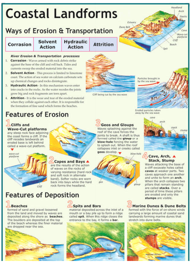
a) Sea cliff: Sea cliff is a very distinctive feature of marine erosion. It is a steep sided slope. Where the sea wave cut is dominant, the cliff foot will be rapidly eroded and cliff retreat will take place. In extreme cases, there occur over hanging cliffs.
The major landforms produced by marine erosion are:
a) Sea cliff: Sea cliff is a very distinctive feature of marine erosion. It is a steep sided slope. Where the sea wave cut is dominant, the cliff foot will be rapidly eroded and cliff retreat will take place. In extreme cases, there occur over hanging cliffs.
b) Wave cut Platform (Abrasions platform or Beach Platform): It is a smooth marine platform cut between ocean waves at a coastline. It has a gentle seaward slope (less than 5°). Its width may extend several hundred meters. The platform (bench) is composed of bare rock or it may contain a temporary deposit of rock-debris, pebbles or sand.
c) Sea Cave: Sea cave is a natural cavity or chamber which develops along the coast due to gradual erosion of rock. Sea caves are more frequently formed in lime stone and chalk rocks as they are enrobed more by solution process. Sea caves are, however, not permanent features as they are destroyed in due course of time.
d) Sea Arch: Sea arch is a natural opening through a mass of rock limestone or boulder clay. When the keystone of the marine arch collapses, the feature becomes a stack.
e) Stack (Needle, Columns, Pillars, Skerries): Stack is an isolated rock monolith or pillar rising steeply form the sea. Formerly, it was a part of the adjoining land but has become isolated form it by wave erosion.
• Transportation work: The eroded materials are transported by sea waves. The backwash or undertow currents pick up the eroded materials and transport them seaward. Thus the transpiration of material takes place form coastland towards sea and form sea towards coast. The material transported by sea waves are silts, ands, gravels, pebbles-cobbles and sometimes boulders, and marine products.
Marine Depositional Landforms
Sediments transported along the shore is deposited in areas of low wave energy and produces a variety of landforms. The main depositional land forms are:
a) Bar: Bar is an elongated deposit of sand, shingle and/or mud etc. occurring parallel to the shoreline and sometimes linked to it.
b) Spit: Spit is a sandy bar projecting from the mainland into open water. Spit are forms by deposition of sediment moved by long shore drift. Connecting bars are formed when bars are so extended that they either joint two headlands or two islands. When a bar connects the mainland with an island, it is known as tombolo.
c) Barrier Islands: Barrier Island are long, offshore islands of sediments, tending parallel to the shore. Almost, invariably, they form long shorelines a adjacent to gently sloping coastal plains, and they typically are separated from the mainland by a logon. Most barrier islands are cut by one or more tidal inlets.
E. Karst Landforms
• The Karst landforms are results of the ground water erosion.
• Water that occupies pores, cavities, cracks and other spaces in the crustal rocks in known as ground or underground water. The main source of underground water is precipitation and melt-water which infiltrates in the rocks.
• The Karst landforms are results of the ground water erosion.
• Water that occupies pores, cavities, cracks and other spaces in the crustal rocks in known as ground or underground water. The main source of underground water is precipitation and melt-water which infiltrates in the rocks.

• Slow moving ground water can dissolve huge quantities of soluble rock and carry it away in solution. It dissolves limestone, rock salt, ad gypsum. In some areas, it is the dominant agent of erosion and produces karst topography, which is characterized by sinkholes, solution valleys, and disappearing streams.
• The work of ground water is however more significant in the regions of karst topography.
• Approximately 15% of the Earth’s land area has developed karst topography with outsatanding examples found in Bosina, Crotia, southern China, Puerto Rico, Yucatan of Mexico, Florida, Australia, Mehalaya, Siberia.
The following conditions are required for a limestone to develop into karst topography:
1. The limestones formation must contain 80% or more calcium carbonate.
2. Complex patterns of joints in limestones.
3. Thick strata of limestone (20 feet or more)
4. Moderate rainfall in the region.
5. Karst topography does not develop in deserts.
• Groundwater erosion starts with water percolating through joints, faults and bedding plains dissolving the soluble rock.
• The precipitation (rainfall, snowfall) creates many kinkholes, which form circular depression. Sinkhole is a funnel shaped depression or sink, in the ground surface of limestone or karst terrain. It is also known as Ponor. If these sinkholes collapse through the roof of an underground cavern, the resultant landform is known as doline.
• A gently rolling limestone plain might be characterized with sink holes and dolines of 2 to 100 m deep and 10 to 1000 m wide.
Karst Erosional Landforms:
The important karst landforms are as follows:
a) Uvalas : Through solution and collapse, dolines may coalesce and form uvalas or valley sinks which are depressions up to several kilometers in diameters.
b) Polje : It is large depression in a karst region with steep sides and flat floor. It is drained by surface water sources. It is termed as open polje, but if drained by means of shallow holes, it is closed Polje. The Livno Polje (Balkan region) is 64 km long and 5 to 11 km wide.
c) Natural Bridge: These are erosional feature in karst topography. They are formed either due to the collapse of roofs of caves or due to disappearance of surface streams.
d) Caves and Caverns: A natural cavity, chamber which leads beneath the surface of the earth generally in a horizontal or obliquely inclined direction. It may be in the form of a passage or a gallery. Most caves are formed in limestone rock, because it is easily dissolved by carbonation. Rainwater dissolves atmosphere carbon dioxide and forms a weak acid. It then percolates through the fractures and bedding plane, slowly dissolving and enlarging the opening plane, slowly dissolving and enlarging the openings. As cave grows larger, they become unstable and tend to collapse.
e) Blind Valley: It is a type of valley in karst topography. It may be occupied by a stream which disappeared underground as the valley lower end as it approaches and enclosing rock well. Cosequently, the valley looks like a dark valley.
f) Tower Karst : Tower karst are steep, cone-shaped hills, In tropical areas, where dissolution is at a maximum because of the abundance of water from heavy rainfall, a particular type of karst topography known as tower karst develops. (e.g South China, Sumatra and Yucatan Peninsula)
Karst Depositional Landforms:
The mineral matter dissolved by groundwater can be deposited in a variety of ways. The most spectacular deposits are stalactites and stalagmites, which are found in caves. Less obvious are the deposits is permeable rocks such as sandstones are the deposits in permeable rock such as sandstones and conglomerates. Here groundwater commonly deposits mineral matter as cement between grains.
The mineral matter dissolved by ground water can be deposited in a variety of ways.
The deposits are known as “Dripstones”. Some of the depositional landforms are given below:
a) Stalactite: These are icicles like forms that hang from the roofs of caves. It is tapering pendent, material descending from a cave ceiling.
b) Stalagmite: A columnar concretion ascending from the floor of a cave. It is formed from the precipitation.
Union and its Territory/Citizenship
Union & its Territory Citizenship
Part-1 of the Constitution deals with the union and its territories from Article-1 to 4
Article 1 (1) describes that; “India that is Bharat shall be the Union of States”.
Article 1 (1) describes that; “India that is Bharat shall be the Union of States”.
Why Union and not Federation?
• This was deliberately done by the drafting committee to make it clear that the Union is not the result from an agreement with the states rather it is the union which created the states. The states have no right to secede under the constitution.
• Though the union is indestructible but the states are destructible in the sense that Parliament can change their name, boundary or create new states.
• The Constitutional provision in 1949, established a three-tier state system under which the constituent units of the Union had no uniform status. They were recognized under four separate categories: Part A, B, C and D of the first schedule.
• Part-A states comprised governor’s provinces of British India.
• Part-B states consisted to nine princely states with legislatures.
• Part-C states comprised chief commissioner’s provinces of British India and some princely states.
• Part-D states consisted of the Andaman & Nicobar Island.
• The Union of India consists of all the states excluding the Union Territories and the Territories of India consists of states as well as union territories.
• Dhar Commission (1948): During this period (1948-49) the southern states were particular on re-organisation of states on linguistic basis. SK Dhar committee was constituted in 1948 that recommended that the rationale for re-organisation of the states should be on the basis of administrative conveniences rather linguistic factors.
• JVP Commission (1949): The Dhar committee recommendation was not accepted by all and to reconsider the recommendation JVP committee was constituted with the Prime Minister Jawaharlal Nehru as a member and Vallabbhai Patel and Pattabhi Sitaramayya as other two members.
• However, JVP Committee also did not favour the linguistic ground. The only exclusion was creation of Andhra Pradesh which had a fair share of geographical area that was dominated by Telugu speaking people from Madras Constituency.
• It suggested that the security, unity, and economic prosperity of the nation as the criteria of reorganisation.
Formation of new states and alteration of boundaries: The Procedure (Art – 2, 3 and 4):
• Article 2: says that the Parliament may by law admit into the Union or establish new states on such terms and conditions as it thinks fit.
• Article 3: empowers Parliament to form new states and can alter the area, boundaries or names of the existing states by a law passed by a simple majority. The bill to the same effect requires prior president’s recommendations.
• The President before introducing the Bill shall refer it to the State Legislature concerned for its opinion within a specified time limit which can be extended.
• The Bill may be introduced even if the opinion has not come. The Parliament is not bound to accept or act upon the views of the State Legislature.
• If the original Bill is intended to be amended it is not necessary to refer the amendments to the State legislature again.
• Article 4: deals with the supplemental, incidental and consequential provisions as may be deemed necessary. By this Parliament may reduce the total number of members of Legislative Assembly even below the limit prescribed in Art 170 (60 members) as done in Goa and Uttarakhand.
• Article 4 also says that the changes made under Art 2 and 3 shall not be deemed to be an amendment of this Constitution for the purpose of Article 368.
The State Reorganisation Commission (SRC) 1953:
• The recommendation of JVP Committee further accelerated the demand for new states on linguistic basis particularly in Telugu speaking area under the leadership of Potti Sriramalu. The agitation took a violent turn with the death of Potti Sriramalu. The Congress ceded the reorganisation of Telugu speaking area in the State of Andhra Pradesh in 1953.
• To make an exhaustive study of the problem, the Government of India set-up the State Reorganisation Commission in 1953 headed by Fazal Ali (with members K M Pannikar and H N Kunzru) which submitted its report in 1955 and suggested linguistic reorganisation of the states.
• This resulted into 7th Amendment to the constitution and passing up of The State Reorganisation Act in 1956 to give effect to the recommendations of the commission.
The recommendations of SRC:
• It suggested the reorganisation of 29 states of various categories into 16 states and 3 union territories abolishing the categories Part-A, B, C and D.
• The general control vested in Government of India by Article 371 (Special provision with respect to the States of Maharashtra and Gujarat)) should be abolished.
The Present Structure of the Union: At present India consists of 29 States and 7 Union Territories with Delhi as National Capital Region (NCR).
Swatchh Bharat Cess
The Swachh Bharat Abhiyan has been launched with the following objectives:
a) Totally eliminate open defecation.
b) Build pit latrines in all homes of those living below poverty line, with 80% cost subsidy.
c) Total eradication of manual scavenging.
d) Recycling and processing of solid waste into energy and other by-products like fertilizer.
e) Improve people’s awareness for proper sanitation and on the importance of personal hygiene.
Thus to ensure that Swachh Bharat Abhiyan is able to meet its stated goals, the government has decided to introduce the Swachh Bharat Cess for raising funds.
Swachh Bharat Cess will come into effect at the rate of 0.5% on all services, which are presently liable to service tax. The proceeds from this cess will be used for financing and promoting Swachh Bharat initiatives.
Swachh Bharat Cess will come into effect from 15th November 2015, at the rate of 0.5% on all services, which are presently liable to service tax. This will translate into a tax of 50 paisa only on every one hundred rupees worth of taxable services. The proceeds from this cess will be used for financing and promoting Swachh Bharat initiatives.
Proceeds of the SBC will be credited to the Consolidated Fund of India, and the Central Government may, after due appropriation made by Parliament, utilize such sums of money for the purposes of financing and promoting Swachh Bharat initiatives or for any other purpose relating thereto.
India declared Maternal and Neonatal Tetanus and Yaws Free by WHO
India has been declared Maternal and Neonatal Tetanus and Yaws Free by WHO.
Maternal and Neonatal Tetanus
• Tetanus occurs when a bacterium, Clostridium tetani, enters the body through an open wound or puncture.
• A newborn can be infected with tetanus due to unhygienic birthing practices, such as cutting the umbilical cord with unsterile instruments or treating it with contaminated dressings.
• Mothers can also be infected with tetanus during unsafe or unsanitary delivery if there are unsanitary conditions where the tetanus spores are present.
• Maternal and neonatal tetanus (MNT) is totally preventable through immunization and hygienic birth practices.
• India has been declared Maternal and Neonatal Tetanus Free by WHO. The elimination of MNT as a public health problem means that the annual rate is less than 1 per 1000 live births.
• Reasons are:
a) Access to immunization, antenatal care services and skilled birth attendance in the most vulnerable populations – the poor, the remote and isolated communities where hygienic obstetric, postnatal practices and other health services were suboptimal or not accessible.
b) India has re-energized national immunization programme and the special immunization weeks.
c) ‘Mission Indradhanush’, helped ensure that children and pregnant women are reached with vaccines.
d) The ‘National Rural Health Mission’ promoted institutional deliveries with a focus on the poor.
e) The ‘Janani Suraksha Yojana’ encouraged women to give birth in a health facility.
However unlike smallpox and polio, tetanus cannot be eradicated as tetanus spores remain stubbornly present in the environment worldwide. As the risk of tetanus persists, government need to continue efforts to ensure that MNTE is maintained – women and children are immunized and clean deliveries and proper cord care activities get a further boost.
Yaws
• Yaws is a chronic disfiguring and debilitating childhood infectious disease caused by Treponema pallidum subspecies pertenue.
• The disease affects skin, bone and cartilage.
• The disease is found primarily in poor communities in warm, humid and tropical forest areas of Africa, Asia, Latin America and the Pacific. The majority of affected populations live at the “end of the road” and therefore have limited access to basic social amenities and health care. Poor socio-economic conditions and personal hygiene (caused by a lack of water and soap for bathing and washing), scanty clothing, and overcrowding facilitate the spread of yaws.
• WHO declared India free of yaws in May 2016.
The ministry plans to sustain the achievements by health system strengthening; high routine immunization coverage and promotion of institutional/clean delivery/clean cord practices and effective surveillance system.
| About WHO:
The World Health Organization (WHO) is a specialized agency of the United Nations that is concerned with international public health. It was established on 7 April 1948, headquartered in Geneva, Switzerland.
Since its creation, it has played a leading role in the eradication of smallpox. Its current priorities include communicable diseases, in particular HIV/AIDS, Ebola, malaria andtuberculosis; the mitigation of the effects of non-communicable diseases; sexual and reproductive health, development, and aging; nutrition, food security and healthy eating; occupational health; substance abuse; and driving the development of reporting, publications, and networking.
The WHO is responsible for the World Health Report, a leading international publication on health, the worldwide World Health Survey, and World Health Day (7 April of every year).
|
Law commission of India
The Law Commission of India is a non-statutory body constituted by the Government of lndia from time to time. The Commission was originally constituted in 1955. Since then the Commission is reconstituted every three years and is usually headed by a retired Supreme Court judge or former Chief Justice of a high court.
The 21st Law Commission has been formed which will consist of a full-time Chairperson, four full-time Members (including a Member-Secretary), Secretary, Department of Legal Affairs as ex-officio Member, Secretary, Legislative Department as ex-officio Member and not more than five part-time Members.
It has been formed for the period of three years w.e.f. 1st September. 2015 to 31st August, 2018.
The Law Commission shall, on a reference made to it by the Central Government or suo-motu, undertake research in law and review of existing laws in India for making reforms therein and enacting new legislations. It shall also undertake studies and research for bringing reforms in the justice delivery systems for elimination of delay in procedures, speedy disposal of cases, reduction in cost of litigation etc. The other functions of the Law Commission shall, inter-alia, include:
• Identification of laws which are no longer relevant and recommending for the repeal of obsolete and unnecessary enactments;
• Suggesting enactment of new legislations as may be necessary to implement the directive principles and to attain the objectives set out in the preamble of the constitution;
• Considering and conveying to the government its views on any subject relating to law and judicial administration that may be specifically referred to it by the government through ministry of law and justice (department of legal affairs);
• Considering the requests for providing research to any foreign countries as may be referred to it by the government through ministry of law & justice (department of legal affairs);
• Preparing and submitting to the central government, from time to time, reports on all issues, matters, studies and research undertaken by it and recommending in such reports for effective measures to be taken by the union or any state; and
• Performing such other functions as may be assigned to it by the central government from time to time.
credits:iasscore

No comments:
Post a Comment